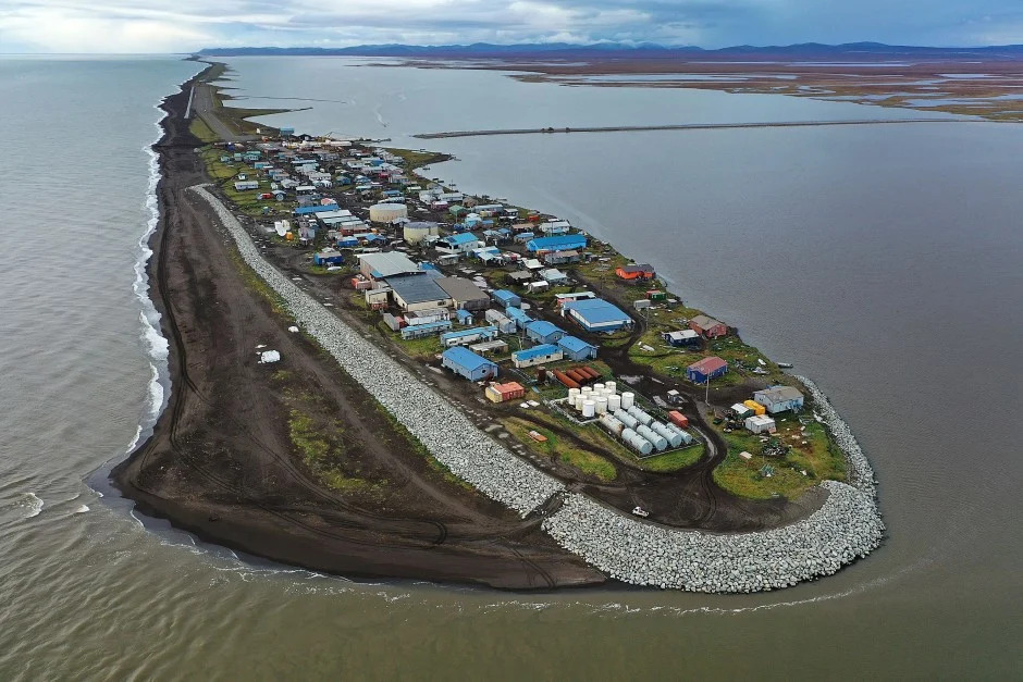
This was as basic of a ROW mapping project as you can get. My role was research, title, legal descriptions and plan review. The bulk of the project, the mapping and parcel plats, was performed by another R&M senior land surveyor. When I say this was a basic project, that is because most ROW plan projects typically start with an intensive base mapping phase where the existing property lines, existing rights-of-way, easements and other title interests are located. From that point, the effort is to define what additional ROW will be required to construct the project. But this was an entirely new road and not an existing one that was to be widened or re-aligned. Given its location on a coastal spit, this new evacuation road would provide Kivalina residents with a reliable evacuation route in the event of a catastrophic storm or ocean surge.

The 7.7 mile long project commences at the Kivalina airport and proceeds northeasterly through lands owned by Nana Regional Corporation to higher ground. Land status issues included an evaluation of RS-2477 rights-of-way, ANCSA 17(b) easements, potential conflicts with the Maritime National Wildlife Refuge boundaries, DNR managed navigable waters and platting obligations.
This project provides a good outline of the basic elements that go into a DOT&PF right-of-way mapping project.
The road construction was substantially complete in October of 2020. The final platting for the new ROW and the final ROW acquisition documents are still pending.
|
7/13/18 |
|
|
n/a |
|
|
12/18/18 |
ROW map Kivialina - Preliminary |
| Plans | |
|
5/2/18 |
|
|
n/a |
Kivalina ROW Map Notes - draft |
|
n/a |
|
|
6/20/18 |
Kivalina Title Review - jfb |
| Plans - Annotated | |
|
n/a |
Calc Diagram from Group 1049 Field Notes - Point numbers |
|
n/a |
Computation Sketch - Point numbers |
| Plans - Annotated - Airport Boundary | |
|
6/12/85 |
|
|
7/3/11 |
|
| Plans - Annotated - Subdivision Plats | |
|
4/3/00 |
215-2000-006-001 - USS 5582 Townsite of Kivalinia |
|
8/7/12 |
215-2012-2012-6 DOWL - Kivalina Erosion Project |
| Plans - Legals | |
|
12/27/18 |
|
| 12/21/18 | |
| 12/20/18 | |
|
12/20/18 |
|
|
9/28/18 |
|
|
12/20/18 |
|
|
12/20/18 |
|
|
12/20/18 |
|
|
12/20/18 |
|
|
12/20/18 |
|
|
12/20/18 |
|
|
9/28/18 |
|
|
9/28/18 |
|
| Plans - Parcel Plats | |
|
10/3/18 |
|
|
12/19/18 |
|
|
12/19/18 |
|
|
12/19/18 |
|
|
12/19/18 |
|
| 12/19/18 | |
| 12/19/18 | |
| 12/19/18 | |
| 12/19/18 | |
| 12/19/18 | |
| 12/19/18 | |
| 12/19/18 | |
| 12/19/18 | |
| Plans - Protracted vs Surveyed | |
|
4.15.05 |
Subdivision of Township Protracted vs. Surveyed Section Lines |
|
8/7/18 |
|
|
n/a |
|
| Plans - Remainder Large | |
|
7/25/18 |
|
|
3/8/04 |
|
|
4/5/11 |
|
|
n/a |
Remainder - Large - note |
| Plans - Title | |
| 11/20/17 |
|
|
11/20/17 |
|
|
11/29/17 |
|
|
11/29/17 |
|
|
11/9/17 |
|
|
8/21/85 |
|
|
11/9/17 |
|
|
11/9/17 |
|
|
11/15/17 |
|
|
11/9/17 |
|
|
11/20/17 |
|
|
11/20/17 |
|
|
4/24/67 |
|
| Research - ANCSA 14c3 | |
|
7/11/96 |
1996 Noorvik 14c - ROW Easement |
|
12/10/09 |
2009 Selawik 14c easement - Easement |
|
6/24/13 |
|
|
1/31/83 |
|
|
12/23/11 |
|
| Research - BLM - 17b | |
|
8/28/98 |
|
|
2/20/08 |
|
|
8/11/08 |
|
|
8/11/08 |
|
| Research - BLM - Conveyances | |
|
3/31/15 |
|
|
3/31/15 |
|
| Research - BLM - MTP | |
|
5/28/15 |
|
|
5/29/15 |
|
|
11/23/15 |
|
|
5/29/15 |
|
| Research - BLM - Protractions | |
|
n/a |
|
|
n/a |
|
| Research - BLM - Twp Survey | |
|
8/28/76 |
|
|
9/2/08 |
|
|
12/28/78 |
|
| 12/28/78 | |
| 12/28/78 | |
| 12/28/78 | |
| Research - BLM - USS | |
|
4/26/95 |
|
|
10/10/61 |
|
|
5/16/77 |
|
|
6/3/82 |
|
|
4/26/95 |
|
|
5/13/81 |
|
|
4/26/95 |
|
|
4/26/95 |
|
|
4/26/95 |
|
|
4/22/82 |
|
|
4/26/95 |
|
|
4/26/95 |
|
|
4/26/95 |
|
|
4/26/95 |
|
|
4/26/95 |
|
|
5/12/82 |
|
|
5/4/81 |
|
| Research - DCRA | |
|
1999 |
|
|
2013 |
|
|
2013 |
|
|
2013 |
|
|
2013 |
|
| Research - Dedication | |
|
8/27/18 |
|
|
8/27/18 |
|
|
n/a |
|
|
1/23/18 |
|
| Research - DNR - Navigable Waters | |
|
5/1988 |
|
|
5/1988 |
|
|
5/1988 |
|
|
n/a |
|
|
n/a |
|
|
n/a |
Kivalina Notes - jfb |
|
5/1988 |
|
| Research - DNR - Reliction | |
|
10/2015 |
|
|
4/16/82 |
|
| Research - DNR - RS2477 | |
|
n/a |
|
|
n/a |
|
| Research - DNR - Tidelands Survey | |
|
n/a |
|
|
5/10/18 |
|
|
2/2002 |
DNR Alaska Tideland Surveys -Alaska Surveying & Mapping Conference |
| Research - DNR - Tidelands Survey - Examples | |
|
1/23/17 |
|
|
8/21/17 |
|
|
2017 |
|
|
5/13/15 |
|
|
9/8/08 |
|
| Research - DOT | |
|
1/19/18 |
|
|
8/27/02 |
|
|
1985 |
|
|
8/28/01 |
|
|
3/10/15 |
|
|
4/19/85 |
|
|
4/19/85 |
|
|
8/21/85 |
|
|
4/24/67 |
|
|
7/3/11 |
|
| Research - FWS | |
|
6/27/18 |
|
|
n/a |
|
|
n/a |
|
| 2011 |
|
|
n/a |
|
|
n/a |
|
|
n/a |
|
|
5/29/15 |
|
|
3/15/72 |
|
| Research - Kivalina Airport | |
|
8/25/01 |
|
|
3/10/15 |
|
|
4/19/85 |
|
|
4/19/85 |
|
|
10/10/61 |
|
| Research - Kivalina Airport - Title | |
|
7/5/85 |
|
|
7/11/01 |
|
|
6/11/85 |
|
|
8/21/85 |
|
|
4/24/67 |
|
| Research - Municipal Certificate | |
|
7/3/69 |
|
| Research - NW Arctic Borough | |
|
n/a |
|
| Research - Other RM Projects - Kivalina Airport Erosion Control | |
|
5/12/14 |
|
|
11/9/16 |
|
|
11/8/16 |
|
| Research - Other RM Projects - Kivalina Sec 22 Evac Road Study | |
|
n/a |
|
|
n/a |
|
|
1952 |
|
| Research - Plats | |
|
4/6/89 |
215-1989-003-001 - Block 10 Kivalina Townsite |
|
4/3/00 |
215-2000-006-001 - Block 10 Kivalina Townsite |
|
4/8/08 |
215-2008-2008-2 - ROW Vacation |
|
9/4/09 |
215-2009-2009-9 - Block 3 & 10 Replat |
|
8/17/12 |
215-2012-2012-6 DOWL - Kivalina Erosion Project |
|
11/9/16 |
Kivalina 16-228 SCD LOCAL 2016-11-09 - Survey Control Diagram |
|
6/18/18 |
|
|
11/9/16 |
|
| Research - USGS | |
|
1952 |
|
|
1952 |
|
|
1955 |
|
|
1955 |
|